From Mercator to Equal Earth: A Turning Point in Map Representation?
World maps shape how we understand space, scale, and even power, yet most people rarely question the projection behind the image. This piece explores why the Mercator projection became dominant, how its distortions influence public perception, and why global institutions are beginning to shift toward fairer alternatives.
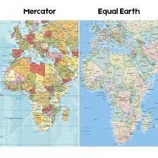
The article highlights the growing conversation around representation in mapping, including the Equal Earth projection, the Correct the Map campaign, and the African Union’s recent endorsement encouraging schools and organizations to reconsider their default world maps. It also explains how Mercator’s navigation-based design differs from modern needs, and why cartographers and educators are calling for projections that better reflect the true scale of continents like Africa and South America.
For geospatial professionals, this moment raises important questions: Which projections support clarity and fairness? How do our design choices influence public understanding? And how can we communicate the importance of map representation in a world increasingly shaped by spatial data?