Writing Portfolio

Stories, interviews, and technical insights across geospatial, Earth observation, and technology.

Interviews

Conversations with geospatial leaders, CEOs, and innovators.

Feature Articles

Long-form stories and editorials on EO and mapping.

Technical

Technical analyses and deep-dive explainers across Earth observation, GNSS, geodesy, positioning systems, and spatial data science.

Interviews

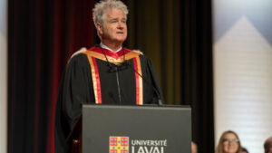
“…Vast, Deep, and in Constant Motion…”: Denis Hains Honoured with Doctorate Honoris Causa

Denis Hains has long been a leading voice in Canada’s hydrospatial community, and his recent conferral of an Honorary Doctorate in Geomatics Sciences from Université…

Read more →

From Curiosity to Climate Action: Nicholas Kellett on Deploying AI for a Changing Planet

Deploy Solutions is a Canadian geospatial company working at the intersection of climate resilience, artificial intelligence, and Earth observation. Founded by Nicholas Kellett, the company…

Read more →

Building What’s Next: Kevin Jones on Innovation and Strategy at Catalyst

Catalyst, formerly known as PCI Geomatics, has been a cornerstone of Canada’s geospatial software landscape for more than forty years. As the industry moves toward…

Read more →

A Lifetime in Radar: Dr. Vernon Singhroy on Innovation, Influence, and Mentorship

Dr. Vernon Singhroy is one of Canada’s most influential Earth Observation scientists, recognized globally for his leadership in radar remote sensing and geohazard monitoring. With…

Read more →

Feature Articles

The Story Beneath the Map

Every time someone opens a map on their phone, they are relying on centuries of ideas, measurements, and technologies that slowly built the foundations of…

Read more →

From Mercator to Equal Earth: A Turning Point in Map Representation?

World maps shape how we understand space, scale, and even power, yet most people rarely question the projection behind the image. This piece explores why…

Read more →

From BIM to Digital Built Ontario: Turning Collaboration into Action

The merger between dbNCR and the Toronto BIM Community marks a major shift in how Ontario approaches digital delivery in the built environment. Together, these…

Read more →

After Landsat 7: Honouring a Legacy, Continuing the Mission

On June 4, 2025, Landsat 7 completed its mission after more than twenty years in orbit, closing a chapter in one of the longest-running Earth…

Read more →

Technical

Inside the CSRS-PPP Galileo Update: Accuracy Gains and What’s Next

Canada’s Precise Point Positioning (PPP) service has entered a new phase with the integration of Galileo, Europe’s satellite navigation system. This update strengthens the Canadian…

Read more →

Re-Centering Canada: Inside the Modernization of the Canadian Spatial Reference System

Canada is preparing for one of the most important updates in its geodetic history: a transition to a modern, fully geocentric reference frame. The shift…

Read more →

Pride in Precision: Montréal’s Real-Time GNSS Network and Its Legacy

Montréal’s Real-Time GNSS Network (RTN) represents a major step forward in Canada’s geodetic modernization. Built over nearly two decades, the system delivers centimeter-level accuracy across…

Read more →

Reference Systems in Transition: A Wake-Up Call for the Geodesy Crisis

North America is preparing for one of the biggest geodetic changes in its history. Agencies in the United States, Canada, and Mexico are moving toward…

Read more →

See more on GoGeomatics

This page highlights a selection of recent work. For the full archive of conference coverage, interviews, and technical articles, visit my author page on GoGeomatics Canada.

View full archive on GoGeomatics →